
 A Picture of the massive storm front at my location July 27th. (looking West)
This post will be separated into 2 parts. one part will cover the storms in the area as a whole, and the second part will cover the storm and damage at my location.
A very Large Line of storms extending all the way from Northern Wisconsin to parts of Nebraska pushed across all of the 6 county area Tuesday. with reports of a lot of Wind Damage, including some significant strait line wind damage, and some damage that was from a tornado. The main damage area seems to be centered around the Balsam Lake, Turtle Lake and Almena areas north to Cumberland, with lesser wind damage south.
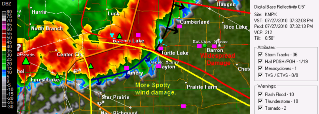
 GRl3 radar image with narrative lines (Pink squares are damage/Strong wind reports) Large image Here
 Tree damage in Turtle Lake Photo by Alan Gabe.
The Community of Turtle Lake just to my north got hit very hard with this storm. My friend reported that there was trees and power lines down in and around Turtle Lake blocking roads, as well as siding torn from parts of a the hotel on the West side of town Highway 63 near Turtle Lake was closed due to fallen trees. with the tornado passing less then 2 miles from town to the North and Northeast the damage to this area was more significant.
Storm at My Location
 Second Image of the Storm front (Looking North towards Turtle Lake)
This line of storms brought Very Strong winds to my area, The strongest winds that I have seen in many years. As the storm came in, I could see a massive storm front ahead of the storm, and in all my years of storm photography i have never seen a wall of clouds above the storm front like this. I could tell by the looks and speed of these clouds, and radar images that the winds were going to be very strong, but it wasn’t until Damage reports came in from Balsam Lake before I realized my home and community was in danger and people needed to be inside, because this storm reminded me a lot of the strait line wind event of June 2001 This is one last image of the storm clouds showing just how threatening the skies looked, I’ve never seen this much green in storms before!
Storm Footage of the strongest winds.
I decided I was to film the winds from our poll shed on the Northwest side of the yard so I could get full view of the trees, but I was glad the winds were not much stronger then they were, because the shed started to rattle under the strength of the winds. I seen the strongest winds came just before the rain hit, just as the huge shelf cloud in the pictures above pasted, It went from dead calm to windy like in this video in the madder of minutes.
Video still of the Backyard tree enduring the strongest gusts Est. at 50MPH
During the strongest winds, Me and my family all thought the tree in the photo above would fall at any moment, the winds were pushing on the tree like never seen before causing cracking and creaking. But thankfully this old ash tree made it through another storm, and we were glad it did because had it fallen, it would have fallen right onto our house. The Strongest gust picked up on my anemometer from the WNW at 39MPH, but my gauge was unfortunately partly blocked by a tree, but I would estimate winds were near 50MPH at my yard with 48MPH gust was reported just to my west. After the the strongest gusts, some wind continued some but really died down after the heavy rain moved in. I picked up 0.70″ of rain in the storm, This storm also had vivid spider web-like cloud to cloud lightning.
Damage at my yard
 Branch damage all over the backyard the next day July 28th.
The Damage from this storm was on the severe storm threshold side in my yard, but I was surprised there was not more significant damage because of the high list of damage reports just north of my community. Scattered live and dead Branches were down all over my backyard, one branch measuring 1 inch in diameter
 Torn Shingles in the yard.
The WNW winds were actually strong enough to tare shingles off of our garage roof, a building that has nothing blocking it from the West. The shingles were found thrown across the yard past our apple tree! but thankfully there wasn’t more then a few that were torn off.
 This is a small poplar tree that was blown down just to the WNW of my house, This tree was 4 inches in diameter. There was also a lot of grass completely flattened just west of my yard in the fields. This will be a storm me and many more across the area I will remember for a long time, I seen many things in this storm I’ve never experienced before.
Damage Reports
Balsam Lake, Garage Damaged, trees up to 5 inches in diameter down.
Confirmed EF-0 Tornado effecting the Village of Balsam Lake.
7 miles N Range, Large pine tree toppled
Turtle Lake, Large trees down onto power lines near intersection of Highway 8 & 63 Highway 63 closed due to down trees
Confirmed EF-1 Tornado effecting rural areas just North of the Village of Turtle Lake.
2 miles S Cumberland, Pine Trees Snapped house with half of roof torn off, Trees down on houses.
2 miles NE of Spooner Large Tree down on cabin.
6 miles S Cumberland, Trees Down
Birchwood Large pine tree fell on cabin and made hole in roof.
2 miles N Turtle Lake power lines down
2 miles N Stone Lake Power lines down
Balsam Lake, 53MPH wind gust
6 miles W Trego several trees down
Amery 48MPH wind gust
1 miles SE Clayton Tree 4 inch in diameter and branches down, shingles torn off garage
2 miles E Barron Trees Down
1 mile W of Barron Trees down, power lines down.
Confirmed EF-1 Effecting rural areas 2 miles N of the City of Chetek.
Connorsville. Tree Down
Menomonie 51MPH wind gust
Cool write up,nice pics…Was a fun storm..Lots of damage though one thing I really don’t like to see… Lots of the storm reports from Barron County were mine I see..Keep up the good work.
Thanks Dirk, yeah it was a messy storm. I called out that the storm would have 50 to 60MPH winds on my blog even before the warning went out. So I was glad I saw this, then trees were reported down in Balsam Lake and the NWS sent out a warning
beautiful blog..pls visit mine and be a follower.. thanks and God bless..
http://forlots.blogspot.com/
Exciting times, D. It’s great that you are able to have such wonderful views of the storms from your property. I do not have that luxury living in the city. I think I need a fourth story observation deck. Keep up the great work on the pictures. Great report as always.
We haven’t had much to talk about lately in my location as far as damaging winds. Flooding is a different story, but we’re drying out slowly but surely.