
 Regional Weather Conditions
Tuesday a warm front pushing in from the west will ignite a chance of thunderstorms across the region, but best chances will be in Minnesota and Northern Iowa and Western Wisconsin, where there is a chance for severe storms. Wednesday, southern Minnesota and Wisconsin southward will be in hot and humid, but with dry sunny conditions. Very warm temps in the mid 90s will be likely in southern Iowa, northern Missouri and much of Nebraska.

Local View
Note: This forecast had some changes. Due the increasing chances at Sun Tuesday I have warmed temperatures up and added the chance for storms, (some heavy) in the morning and again in the afternoon.

Metro View
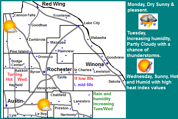
For the Rochester Metro we can expect Monday to be sunny and a bit warm with highs approaching the mid 80s in the city, with lows remaining in the upper 60s. Tuesday the best chance of rain will start in the early morning and again in the afternoon, and some could be heavy and be strong to severe. Skies will clear Tuesday afternoon and it will be hot and humid, highs will likely be 90.F or higher in the city, with heat index’s in the mid to upper 90s. Tuesday lows will be in the 70s. Wednesday will be a hot and sunny one for Rochester again, highs in the city will reach the upper 80s with the potential to reach 90.F again, heat index values could rise in the to mid 90s, but humidity should slowly wane.
Forecast
Monday, Sunny skies. Highs in the low 80s to mid 80s, Monday Night, increasing humidity, partly cloudy with lows in the mid 60s to upper 60s.
Tuesday, Hot and Humid, a chance of thunderstorms in the morning then again in the afternoon, some could be strong to severe and produce heavy rain, otherwise Partly Cloudy , Highs in the mid 80s to upper 80s with low 90s, in the Rochester Metro. Heat Index Values in the mid to upper 90s. Tuesday Night, Mostly Cloudy, lows in the upper 60s to low 70s.
Wednesday, Clearing skies hot and humid. Highs in the mid to upper 80s with heat index values in the 90s. Highs upper 80s to 90.F Rochester Metro. Wednesday Night, Partly Cloudy, Cooler, Mid 60s, upper 60s Rochester Metro.
Looking Ahead
Warm conditions will continue Thursday all the way through next weekend. There will be a couple more chances at some heavy storms, one chance on Saturday the 27th and another chance with a strong cold front on Monday the 29th. for the last day of August it will be much cooler with lots of sunshine, these conditions last into the early part of September, before warmer air gets pushed into the region by Saturday Sept 3rd. There appear to be another chance of a pretty large storm system as we approaching the 4th and 5th of September, with a big cool down, Far Northern Minnesota may have frost chances.